

LandGlide: GPS Property Finder is a mapping application that provides detailed property information and boundaries using GPS technology. It allows users to identify property lines, ownership details, parcel numbers, and zoning information directly on a mobile device. Designed for real estate professionals, landowners, and outdoor enthusiasts, the app offers offline maps, precise GPS tracking, and high-resolution parcel overlays. Users can search by address, owner name, or parcel ID to quickly access land data. By combining comprehensive property insights with user-friendly mapping tools, LandGlide simplifies property research, planning, and navigation in both urban and rural areas.
Key Features
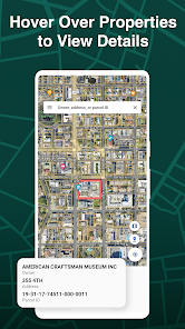
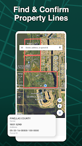
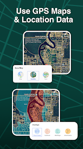
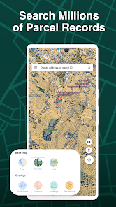
Accurate GPS mapping of property boundaries.
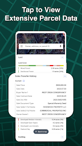
Access to ownership and parcel details.
Offline map availability for remote areas.
Search by address, owner, or parcel ID.
High-resolution parcel overlays.
Navigation and location tracking.
Property measurement and area calculation tools.
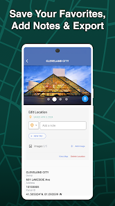
Bookmark and save favorite properties.
User-friendly interface for easy navigation.
Regular data updates for accuracy.
Pros & Cons
Pros:
Provides detailed property and ownership data.
Works offline for remote locations.
Simple and intuitive navigation tools.
Accurate GPS positioning for land research.
Supports property planning and measurement.
Cons:
Premium subscription required for full access.
Limited functionality in areas with incomplete data.
Learning curve for advanced mapping tools.
Functions
Displays property boundaries on GPS maps.
Provides parcel and ownership information.
Tracks location and allows offline navigation.
Measures land area and distances.
Stores and bookmarks property searches.
Updates maps with accurate property data.
How to Use
Click the button ""Check All Versions"" below to download and install it.
Open the app and enable GPS access.
Search for properties by address, owner, or parcel ID.
View property boundaries and ownership information.
Use measurement tools to calculate area or distances.
Bookmark favorite properties for future reference.
Access offline maps in remote locations.


 0
0